4th Edition Book Overview
Why take a chance on a hike that might not suit your needs?
This book, now redesigned, reshaped and updated with new hikes, narrows your choices to the best of what the
Smokies offer from human history to splendid scenery. That’s what
this book is for-to help you make the most of your precious time
while in this national park. It offers
23 there
and back day hikes, 10 day loop hikes, and 10 two night overnight
loops for the weekend backpacker.
The Great Smoky Mountains National Park: 500,000 acres
in size, 850 miles of trails, 270 miles of roads, 9,000,000 or so
annual visitors. It is the most visited national park in the
American system, perhaps the world. It’s variance of forests is
unmatched in the temperate climate zone. The park boasts seven
trees of record dimensions among the upwards of 130 species of trees
that grow here. In this land of superlatives thrive, 25 species of
salamanders, 50 species of mammals, 80 species of fish, 200 species
of birds, 1,300 species of flowering plants, 2,000 species of fungi,
and more. This biodiversity is one of the primary reasons for its
impressive designation as national park and an international
biosphere reserve.With the overwhelming mileage of trails, an
uninformed hiker in the park is faced with a hit or miss choice of
hikes. Weather, season, and day of the week can make a trail
alluring or as overcrowded as Newfound Gap Road on a weekend summer
day.
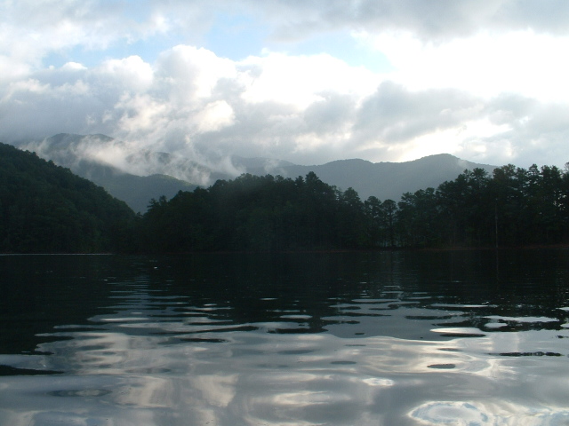
Fontana Lake
Book Excerpt Fontana Lake Overnight Loop
| Scenery |
5 |
| Trail Conditions |
4 |
| Difficulty |
2 |
| Solitude |
2 |
| Children |
4 |
| Distance |
4.7, 6.8, 6.2 miles each day |
| Hiking Time |
2:45, 4:00, 3:45 |
| Outstanding Features |
lakeside camping human history, good initiation backpack |
If you like a combination of mountains and lakes, this moderate hike is for you and any younger or inexperienced backpackers you may wish to bring along. Start your trip on a boat that takes you on the pleasure ride from Fontana Marina to Hazel Creek. Hike up a modest grade on the Lakeshore trail through a valley steeped in settler and logging history to camp at Sugar Fork, one of the Smokies best campsites. Then, cross over Jenkins Trail Ridge to the Eagle Creek watershed and camp right where Eagle Creek spills into Fontana Lake, to simultaneously enjoy a tumbling stream and a mountain rimmed lake. On the way back, pass more human history, still on the Lakeshore trail, to intersect the Appalachian Trail, and walk over Fontana Dam, the highest in the East, to the Fontana Marina.
Before you leave, contact Fontana Marina at (704) 498-2211, extension #277, to arrange for a one way shuttle, you'll hike back to the marina. Start your trip at the mouth of Hazel Creek on the Lakeshore trail. Pass the Proctor Creek backcountry campsite, #86, at mile .5. Soon, cross Hazel Creek on a wide bridge; the house across the creek is park owned and used. Hike along the jeep road and watch for the many signs of the homestead and logging days. On your left at mile 1.2 is the old Proctor cemetery.
As you hike, the scenic mountain stream comes into view and is always heard. Cross two wide bridges before arriving at Sawdust Pile backcountry campsite, #85, at mile 3.3 on your right. Span two more bridges before coming to a trail junction at mile 4.5. To your right, just across the bridge over Sugar Fork, is the Sugar Fork backcountry campsite, #84, elevation 2,160. This is your first night's destination.
Nestled between Sugar Fork and Hazel Creeks, this level campsite beneath the pines makes an ideal base camp for the angler or amateur archaeologist. A thick metal wire is strung between two trees at the camp to aid you in hanging your food from bears and raccoons, both of which have presented problems at this campsite in the past.
Start day two by crossing the wooden bridge over Sugar Fork and rejoining the Lakeshore trail as it heads west over Jenkins Trail Ridge. Follow an old road high above Sugar Fork, passing a side trail on your left to the Higdon Cemetery, at mile 5.0 of your loop hike. As you climb, notice how well the forest has recovered from being completely logged in the first quarter of the 20th century. At mile 6.2, on the right, up Little Fork is the site of an old copper mine and homestead. More climbing leads to Pickens Gap on Jenkins trail ridge, and a trail junction, at mile 6.9.
Stay on the Lakeshore trail and begin descending fairly steeply on switchbacks. At mile 7.5, cross Pinnacle Creek, for the first of 16 times, many of which could be wet crossings. Continue descending along the north bank of Pinnacle Creek to
pass the old Pinnacle Creek backcountry campsite at mile 9.1. Just beyond the campsite is where the Lakeshore trail and Pinnacle Creek merge into one, the Lakeshore trail crossing and recrossing Pinnacle Creek on the journey to Eagle Creek.
Emerge from the junglesque rhododendron thickets of Pinnacle Creek to reach Eagle Creek at mile 10.5. Thankfully, a very long footlog spans Eagle Creek and spares you one more ford. Cross Eagle Creek and immediately come to the Eagle Creek trail junction. Turn left and stay on the Lakeshore trail, which now parallels Eagle Creek.
Cross Eagle Creek on a another footlog, then on a new metal frame bridge at mile 10.8. Veer right and the lake comes into view on your left. Pass over Lost Cove Creek on a footlog to arrive at Lost Cove backcountry campsite, #90, elevation 1,760, at mile 11.3. This is your second night's destination. This popular campsite extends out beyond the trees and offers fishing and swimming in both Fontana Lake and mountain streams nearby.
Start day three by finding the Lost Cove trail. As you look out on the lake from the campsite, the Lost Cove trail will be uphill and to your right. .4 mile on your left, up the Lost Cove trail, is the Lakeshore trail junction. Turn left up the Lakeshore trail. This portion of the Lakeshore trail has many old roads and trails leading off it so make sure you stay on the right trail. Fontana Lake will be on your left the whole way.
Begin walking a pattern the trail will follow: up and around a point of a ridge and down into a creek filled hollow, up the side of a ridge and over the point and down into a hollow again. At mile 14.6 of your loop hike, intersect an old road that still has some junker cars from the 1930ís nearby. Homesites and other evidence of man's hand are all about this section of trail. Leave the old road at mile 16.4, to climb to another old road that leads out to Fontana Dam Road at mile 17.1.
Come to the north side of Fontana Dam at mile 17.7, intersecting the Appalachian Trail along the way. Follow the A.T. to the left away from Fontana Dam Road and pass a trail shelter, known as the Fontana Hilton, because it is so nice. After a brief time in the woods, the A.T. crosses a road leading to the marina. The marina is a short distance downhill to your left. Turn left on the road and complete your loop.
Directions: From Townsend, Tennessee, take U.S.321 north to the Foothills Parkway. Follow Foothills Parkway west to U.S. 129. Turn south on U.S. 129 into North Carolina. Turn left on N.C. 28 passing Fontana Village. 1.5 miles past Fontana Village entrance, turn left at sign to Fontana Dam. Then turn right at sign to Fontana Village
Marina, a short distance away. From Bryson City, N.C., take U.S. 19
south to N.C. 28. Follow N.C. 28 for nearly 25 miles to turn right
at sign to Fontana Dam, then right to Fontana Village Marina. |