|
Click on the book cover to order!
|
A Paddler's Guide to Everglades National Park, 2nd edition
Complete guide to canoeing and kayaking the Everglades, covering 400+ miles of ocean, river, bay, & creek waters along 53 designated routes, including Wilderness Waterway. Itineraries for day trips, week-long excursions, & little-known passages. |
|
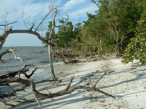
Beach at Hog Key
Sample Paddling Route Below Turkey Key Route Begin: Mormon Key End: Lostmans River Ranger Station at Lostmans River Distance: 11 miles Time: 6 hours Potential Tidal Influence: 5 Potential Wind Influence: 5 Navigational Challenge: 2 Highlights: Beach campsites, historic islands Hazards: Strong winds and big waves in the Gulf Campsites: Mormon Key, New Turkey Key, Turkey Key, Hog Key Connections: Pavilion Key Route, Chatham River Route, Highland Beach Route, Lostmans River Route This route encompasses several island campsites and even more keys as it heads down the Gulf to Lostmans Ranger Station at the mouth of the Lostmans River. Many of these islands were once inhabited but have reverted to a more wild state. The points of these keys are often sandy while the bulk of the isles are mangrove. There are shallows scattered among the islands that can be exposed at low tide, and it can be extremely shallow by the mainland at all times. The mainland along this route is mangrove with an occasional bit of beach, with gnarled bleached trees adding the setting. The wind may play a role in the exact paddle path you choose on this route. There are four campsites along the way, meaning you can stretch this leg of your journey out for days. Fishing can also be productive in these keys. Start your route by leaving Mormon Key, where there is a fine backcountry campsite, and paddling around the west side of the island. Start south for a crowded group of keys. At low tide, you will have to stay on the Gulf side to keep from running aground, but bisect the keys if possible for the most scenery. Once past these islands, aim for the channel between New Turkey Key and an unnamed mangrove key closer to the mainland. Tall pilings mark the channel. Watch for motorboats here. The best approach to the New Turkey Key campsite is from the southeast, beyond the pilings. The primary camping area here is on the mainland side of this slender island, two miles beyond Mormon Key. {fig 4} Paddle southeast from New Turkey Key to Turkey Key. The island, one mile distant, is visible, and the signed camping area is directly in front of you, on the key's west side. I once spent two days here, trapped by gale force winds. In pre park days, this was a rendezvous point for fishermen who would turn in their catch to a boat from Chokoloskee and would receive supplies from the same boat. It is now an excellent paddlers camp that has a shallow approach, discouraging motor boaters. Leave Turkey Key and paddle south past Buzzard Key into the Plover Keys. This is an attractive group of islands with scattered beach areas among the mangrove. The southeast side of Plover Key has the most extensive section of beach among these islands. Continue down the coast aiming for Bird Key. Our feathered friends inhabit this island still. The combination of nearby food and relative safety from predators make this an attractive key for them. The beach at Porpoise Point on Wood Key is visible from Bird Key. But first will come Boggess Point, facing west into the Gulf. If the winds are strong you may want to take the inside route by Toms Bight. Either way pass Wood Key and look for coconut palms on the island's south side. They are a reminder of the days when this island was occupied by several families. There was once even a small school here. Traverse Wood Key Cove to Hog Key, arriving at mile 8. Here is an attractive beach campsite backed by Spanish bayonet, and especially large sea grape. There are still hogs on Hog Key. Also note the large spreading tamarind tree. Leave Hog Key and swing southeast beside a long point of land leading into Lostmans River. At some pilings on a point, come to the Lostmans Ranger Station. The station tower will be visible before the ranger station. This sandy high ground of the ranger station is fairly extensive. I have seen deer here before. End your route at mile 11. From here it is 4 miles south to Highland Beach on the Highland Beach Route. It is 6 miles east to the Wilderness Waterway at marker #52 on the Lostmans River Route. |
|