Book Overview
The
shortest at 26 miles, the Wild Azalea Trail, is Louisiana’s longest
footpath. It will surprise as it rambles over pine covered hills
into lush bottomlands through which clear, sand-bottomed streams
flow. The 41-mile Black Creek Trail of Mississippi runs along the
course of the federally designated Wild and Scenic Black Creek.
Three sections of the Florida Trail are included. The first 42-mile
section traverses the Big Cypress National Preserve, where you will
be introduced to “swamp slogging” while crossing sawgrass prairies
broken by lush tree islands of palm, cypress and pine. There is
simply no other hiking experience in the United States to match it.
Farther north, a 60-mile parcel of the Florida Trail runs through
the Ocala National Forest, where the world’s largest remaining tract
of the unique sand pine scrub forest remains. The Apalachicola
National Forest offers the 66-mile FT in a longleaf pine/wiregrass
ecosystem divided by lush, junglesque forests growing along dark
streams. Some may chuckle at such a notion, but after hiking the
104-mile Pinhoti, you will be singing this tune as well. And then
there is the 85-mile Foothills Trail of South Carolina and North
Carolina. This path will stun first time visitors. Georgia boasts
two long trails, the Benton MacKaye Trail and the Bartram Trail.
The 93-mile Benton MacKaye begins where the Appalachian Trail
begins, Springer Mountain, and heads north along the western rim of
the Appalachians. The Bartram Trail, at 110 miles, offers the
longest continuous long trail trek.
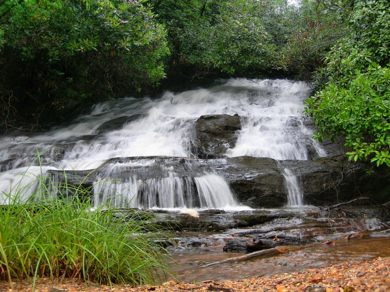
Lick Log Creek Falls
Foothills Trail
One Segment: Oconee State Park to Burrells Ford
| Length |
16.4 miles |
| Trail Condition |
Excellent |
| Highs |
Chattooga Wild and Scenic River, some views,
Big Bend Falls, Kings Creek Falls |
| Lows |
Limited camping first eight miles |
| Season |
Year-round; lowlands away from water can be
uncomfortably hot in summer |
| Difficulty |
Moderate, lots of short ups and downs |
| Use |
Heavy near Chattooga River, moderate
elsewhere |
| Tips |
Consider car camping at Oconee State Park
and getting an early start the next day in order to make it
to Chattooga River watershed to camp |
Oconee State Park Trailhead
From Walhalla, South Carolina, drive north on South Carolina 28 north for 8.5
miles to SC 107. Turn right on SC 107 and follow it 2.5 miles to the state park,
on your right. From here, follow the signs through the park to the Foothills
Trail, on the road to cabins 7-13.
Burrells Ford Trailhead
From Walhalla, South Carolina, drive north on SC 28 for 8.5 miles to SC 107.
Turn right on SC 107 and follow it for 8.9 miles to gravel Forest Road 708. Turn
left on FR 708 and descend for 3 miles. Burrells Ford parking area will be on
your left. The Foothills Trail crosses FR 708 just before reaching the parking
area.
This most southwesterly section of the Foothills Trail starts at
one of South Carolina’s oldest state parks, a destination in its own
right. Oconee State Park makes for a good jumping off point, whether
you stay in the campground, with full amenities, or go upscale with
one of their rental cabins. The Foothills Trail begins in piney
woods near Stratton Mountain. Leave Station Mountain for Long
Mountain, which offers views from its steep slopes, before dropping
to the superlatively attractive Chattooga River. It is unusual to
see rivers of this size being federally designated as wild and
scenic in the East. However, the Foothills River doesn’t stay beside
the river for long, as it climbs over a knob on a river bend. Make
your way along Rock Gorge before resuming the river’s edge. At times
the trail becomes so close that it is nearly in the river, as it
passes through wooded flats and over small side streams with that
everywhere-you-look beauty. Leave the Chattooga again in the
vicinity of Round Top only to drop down to the river near Big Bend
Falls, a surging force of water pinched between walls of the gorge.
Beyond here, the trail stays fairly close to the Chattooga, until it
enters the Kings Creek Valley. Here, a side trail leads a short
piece to the “must see” Kings Creek Falls. Beyond Kings Creek the
trail pulls away from the Chattooga to soon reach the Burrells Ford
parking area. Burrells Ford is a walk-in camping area that used to
have auto access until the Chattooga was designated as wild and
scenic in 1974. This designation restricted auto access. Camping,
fishing and wildlife viewing opportunities are numerous along the
Chattooga. However, no camping is allowed outside of the campground
at Oconee State Park. The section of the Sumter National Forest
outside the Chattooga requires a free permit, which can be obtained
by calling (864) 638-9568. Please call two weeks in advance. In
truth, there is no good camping until 8 miles in, near Sumter’s Lick
Log Creek.
The white-blazed Foothills Trail starts inauspiciously near the Oconee State
Park cabins. Make sure and register at the self-registration board near the
parking area. Begin the trail across the road from the parking area and enter
pine-oak woods. The Hidden Falls Trail runs in conjunction with the Foothills
Trail. Reach a junction at .4 mile. The Tamassee Knob Trail leads right 1.6
miles to Tamassee Knob. Veer left here and work around the headwaters of Horse
Bone Branch to make the south end of Long Mountain. Leave the state park and
enter the Sumter National Forest at mile 1.2, then intersect a closed road. Keep
forward here as the Hidden Falls Trail leaves right. At mile 2.0, a side trail
leaves left for the Long Mountain fire tower. The tower is closed to the public
but the peak does offer wintertime views. Beyond this, other views open to the
east before the Foothills Trail dips over to the west side of Long Mountain and
works its way down toward Clear Branch, then over a couple of wooden bridges
down the narrow upper reaches of Tamassee Creek. Head away from the creek up a
steep hollow. Once out of the hollow, views open to the southeast. The trail
reaches SC 107 at mile 4.6. Do not cross the road, rather, stay right and
immediately reenter the woods, heading up a timber road. Soon veer off the
timber road in piney woods and work around the east slope of Dodge Mountain.
Views open through the trees to your right. Bisect an old logging road at mile
5.5, then turn left away from the ridgeline, reaching gravel Cheohee Road at
mile 5.9. Cross the road at an angle, soon reaching SC 107 at mile 6.0.
Cross SC 107, and circle around the south end of Chattooga Ridge, picking up
a streamlet feeding Lick Log Creek in woods of tall white pine. Turn north,
paralleling Lick Log Creek below. Span a bridge at mile 6.8 and reach a
junction. A side trail leads left 200 yards to the Thrift Lake parking area.
Span another small branch before reaching the Nicholson Ford parking area at
mile 7.5. Keep descending, now along noisy Pigpen Branch, to reach a camping
spot in a grove of white pine at mile 8.0. Immediately span Lick Log Creek on a
footbridge and pass more camping areas to span Lick Log Creek again. Make a
short but steep descent to reach an important trail junction at mile 8.3. You
have now entered the Chattooga Wild and Scenic River corridor. This boundary is
marked with light blue blazes. Here, the yellow-blazed Bartram Trail (This part
of the Bartram Trail is no longer recognized by Sumter National Forest), running
in conjunction with the dark blue-blazed Chattooga Trail, leads left to cross
Lick Log Creek just below Lick Log Falls a short distance away. The Bartram/Chattooga
Trail then heads downstream on the Chattooga River. The Foothills Trail, also
now running in conjunction with the Chattooga Trail, leads right, along the edge
the Chattooga River Gorge on a rocky rooty path alongside rock bluffs, ranging
far above the audible Chattooga. Top out at mile 8.7. Trace an old woods road
through hickories and oaks, cutting over a knob that the river works around.
Pass huge hemlock trees as you descend to make the Chattooga at mile 10.1. The
wild and scenic river froths and crashes over rocks, then gathers in pools,
building steam, before continuing its tortured journey downstream. A streamside
flat has campsites, especially near Simms Field, a formerly settled area and
historically used campsite. A riverside beach and large swimming hole marks
Simms Field, which is reach just after a footbridge at mile 10.9. The trail
stays along the river, so close that at times the path may be under water when
the water is up. Reach another beach across from a rock bluff at mile 11.3. The
trail soon leaves the river and works around Round Knob on a steep mountainside
before intersecting the side trail to Big Bend Falls at mile 12.8. This rough,
unmarked side path dips below a rockhouse to reach the upper part of the huge
crashing falls. Switchback away from the river before descending past Fraser
magnolias and rock formations to once again near the river at mile 13.1. Short
side trails lead to the water. The Foothills Trail crosses an eroded roadbed at
an angle and passes a small falls of a feeder branch just before reaching a
trail junction at mile 13.6. Here, the Big Bend Trail leads right 2.7 miles to
Cherry Hill campground. The Foothills/Chattooga Trail bridges a small branch
above a 6-foot cascade. Drop alongside the Chattooga River, rock hopping
upstream at the water’s edge. Look around and grasp the absolute beauty of this
river. A rough, high water route circumvents this section. Keep upstream and
make a flat with camping possibilities on a riverbend at mile 14.4. Switchback
up the side of the gorge in heavy rhododendron among rock outcrops, then turn
into the King Creek watershed, picking up an old wagon road to reach a trail
junction at mile 15.3. The Foothills Trail veers uphill to the right, and the
Chattooga Trail keeps forward to reach Burrells Ford Walk-in Campground. Keep
with the white blazes to reach another junction at mile 15.7. A spur trail
leaves right .2 mile to King Creek Falls. Don’t bypass this 80-foot drop into a
clear pool. The Foothills Trail heads downstream to span Kings Creek, then
climbs away from the stream to meet Burrells Ford Road, Forest Road 807, at
mile16.4. Just before the road, a spur trail leads forward to make the Burrells
Ford parking area. The Foothills Trail turns right to cross FR 807 and head for
Medlin Mountain. |