This book details the 282 miles of
Kentucky’s master path, the Sheltowee Trace. This path was the 100th
designated federal national recreation trail, dedicated in June of 1979. Hikers who tread this trail will be
“following the turtle,” a white painted turtle blazed on trees, extending from
the trail’s southern terminus in Tennessee’s Pickett State Park, north through
the Big South Fork National River and Recreation Area and on through the length
of the Daniel Boone National Forest nearly to the state of Ohio.
Along the way, hikers will see the best of
the Cumberland Plateau, from exquisite aches to bluffs that offer extensive
vistas to waterfalls that descend into sandstone cathedrals. The path treads
through deep forests in gorges cut by creeks and rivers and atop the Plateau,
where oak and pine forests range long distances. Rock houses, caves and other
rock features stand out in these rich woodlands. Some areas through which the
Trace travels are set aside purely for their natural beauty, such as Cumberland
Falls State Park, the Big South Fork National River and Recreation Area, the
Clifty Wilderness, and Red River Gorge Geological Area. With the protection of
these areas has come protection of the plants and animals that live here,
including threatened and endangered species such as the red-cockaded woodpecker,
Virginia big-eared bat, freshwater mussels, and white-haired goldenrod. The
black bear has made a comeback in these parts, expanding its range into eastern
Kentucky from neighboring states, as well as being reintroduced into the Big
South Fork.
Starting at Pickett State Park, the Trace
starts off with a bang, passing spectacular natural features amid
an everywhere-you-look beauty. In its first mile, ST passes a waterfall, an
arch, and a rockhouse while making its way through the Hidden Passage. Rocky
vistas are had from Thompson Overlook before reaching the Big South Fork
National River and Recreation Area and Rock Creek, a designated Kentucky Wild
River. The ST then reaches Mark Branch Falls, an 80-foot veil of water dropping
into an amphitheater of sandstone. Mining history lies ahead along Grassy
Fork. Here the Trace follows an old mining railroad grade before reaching the
big water of the Big South Fork.
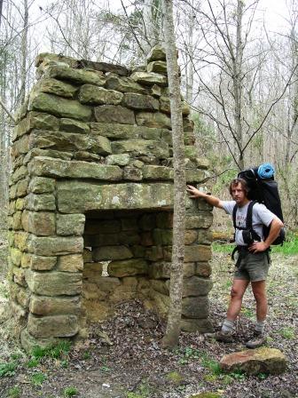
Johhny at an old homesite along the Big South Fork
The Big South Fork River corridor offers sights of its own, such as Yahoo Falls
Scenic Area. Yahoo Falls, the highest waterfall in the state of Kentucky
at 113 feet, is the centerpiece of this picturesque spot. A set of side
trails lead past rock monoliths, Yahoo Arch, overlooks and other cascades.
Beyond here, the trail continues along Lake Cumberland, then heads up
North Fork Big Creek where the Sheltowee Trail makes a 180-degree curve beneath
a deep rock shelter while being serenaded by a waterfall.
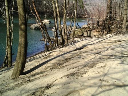
The Trace Along the Big South Fork
The Trace keeps north along the Cumberland
River to see Kentucky’s most powerful falls, Cumberland Falls, roar over a
sandstone ledge, then meander through a boulder garden of designated state wild
river beauty in the Cumberland River gorge. The Trace leaves the Cumberland
River Valley and heads east over to Laurel River Lake, curving along coves and
bays through pine-oak-hickory woods.
Beyond Laurel River Lake, the Trace enters
the rugged Cane Creek watershed, where rockhouses, waterfalls and sandstone
bluffs await. The Sheltowee Trace then enters the Rockcastle Hills and the
superlatively attractive Hawk Creek Valley. Join the famed Wilderness
Road beyond Cromer Ridge, which Daniel Boone and thousands of future Kentuckians
followed to settle the Bluegrass State. Climb past Wildcat Mountain Battlefield
National Monument, site of Kentucky’s first Civil War engagement, then walk high
ridge of oaks and hickories before spanning the Rockcastle River to join
Kentucky 89, a designated Kentucky Scenic Byway. The walking picks up beyond
Turkey Foot, as the Trace enters War Fork gorge. Pass Resurgence Cave, from
which War Fork flows. Turn away from War Fork via Alcorn Branch, passing rock
shelters and a waterfall. The Trace travels the little-visited Copperas Cave
Branch basin, before road walking along big Sturgeon Creek to reach Heidelburg
and the Kentucky River.
Later, the Trace traces high Big Bend
Ridge with views from the “The Narrows,” a narrow rock strip. The Trace enters
Natural Bridge State Park, with its Natural Bridge and Balanced Rock, among
other natural features. The ST reenters national forest land and nears massive
Whittleton Arch. Ahead lies the famed Red River Gorge Geological Area and its
accompanying crowds. Here, the Trace runs along high ridges with views, before
dropping into Chimney Top Creek and spanning the Red River, Kentucky’s only
federally designated wild and scenic river.
The Trace heads up the rugged north side
of the Red River Gorge past spectacular rock houses, small creeks, over a rocky
ridge with far off views and by an arch. The Trace drops into the Clifty
Wilderness. Clear Creek Recreation Area lies in the lowlands, where a fishing
lake borders the remains of an historic iron furnace. Leave Clear Creek and
resume ridge walking far above Cave Run Lake, an impoundment of the Licking
River. The Sheltowee Trace is the master path of a trail network covering the
western shore of the Cave Run Lake.
North of Cave Run Lake Dam the Trace winds
along the spine of narrow wooded ridges, over knobs and down to gaps. Hikers
can look back on Cave Run Lake before dropping off to Triplett Creek and lush
bottomland. The Trace makes a final extended ridge run before
reaching its northern terminus near the upper end of North Fork Triplett Creek.
Through hikers will savor this spot, as it marks the completion of Kentucky’s
master path.
Kentucky is lucky to have been an early
forerunner of the long trail movement, the Sheltowee Trace. This long trail
movement is expanding all over the United States, joining such paths as
South Carolina’s Foothills Trail, the Florida Trail, and the Benton MacKaye
Trail, named for the man with the original idea for the original long trail, the
Appalachian Trail. In other areas, national forest personnel set about laying
out long trails of their own, such as the Black Creek Trail in Mississippi’s De
Soto National Forest and the Pinhoti Trail of Alabama’s Talladega National
Forest. Rangers of Kentucky’s Daniel Boone National Forest were primarily
responsible for development of the Sheltowee Trace. Hopefully, Kentucky’s
master path will continue to evolve and improve for the better, making the
Bluegrass State proud of its own long trail. |
