Book Overview
This book details 50 hikes
that take place in the North Georgia Mountains, from Cloudland
Canyon near the Alabama state line to the Chattooga River on the
South Carolina border and throughout the mountains between.  Specific emphasis was placed on the most scenic destinations and
unique places that make the North Georgia Mountains so special,
places like Springer Mountain, the southern terminus of the master
path of the East, the Appalachian Trail. Many hikes in this book
take place on the AT. Other hikes take place in the 10 designated
wildernesses within the mountains, from the famed Cohutta and to the
lesser visited Southern Nantahala Wilderness. Hikes of varied
lengths and difficulties are included.
Specific emphasis was placed on the most scenic destinations and
unique places that make the North Georgia Mountains so special,
places like Springer Mountain, the southern terminus of the master
path of the East, the Appalachian Trail. Many hikes in this book
take place on the AT. Other hikes take place in the 10 designated
wildernesses within the mountains, from the famed Cohutta and to the
lesser visited Southern Nantahala Wilderness. Hikes of varied
lengths and difficulties are included.
Falls on Dodd Creek
This book will
help you make every step count, whether you are leading the family
on a brief day hike or undertaking a challenging backpack into the
reaches. With your precious time and the knowledge imparted to you,
your outdoor experience will be realized to its fullest.
Hike Excerpt
Rabun Bald and Flat Top
Mountain via Bartram Trail
Total
Distance: 9.0 miles there and back
Hiking
Time: 6:30
Vertical
Rise: 1300 feet
Rating: Difficult
Maps: USGS 7.5’ Rabun Bald, Chattahoochee National
Forest map
This is an isolated and
forgotten part of the Bartram Trail (BT) that travels to two of my
favorite vista spots in the Southern Appalachians. A long gravel
road drive leads to Wilson Gap and the hike’s starting point. From
here, the Bartram Trail travels north to a view of the rock face of
Flat Top
 Mountain,
where you will be standing and looking south. From there, the hike
has some ups and down, eventually leading to the final up and Rabun
Bald, where a stone tower awaits with 360 degree views, and superior
to none for backcountry vistas in the Peach State. Campsites with
water along the way make this a great one-night backpack. Be
apprised that the drive to the trailhead includes an auto ford of
Sarahs Creek that is best suited for high clearance vehicles. Mountain,
where you will be standing and looking south. From there, the hike
has some ups and down, eventually leading to the final up and Rabun
Bald, where a stone tower awaits with 360 degree views, and superior
to none for backcountry vistas in the Peach State. Campsites with
water along the way make this a great one-night backpack. Be
apprised that the drive to the trailhead includes an auto ford of
Sarahs Creek that is best suited for high clearance vehicles.
The Hike
If you want to day hike this
trek, and not backpack, consider car camping down at Sarahs Creek
Campground, which you pass along the way. It has some attractive
sites with lots of privacy and is located along the pretty and
crystalline trout stream of Sarahs Creek. The hike leaves north from
Forest Road 155 on a single-track path in gorgeous woods. It has
just the right mix of tree species and brush that it could only be
landscaped by Mother Nature. Doubletop stands off to your right.
Begin moderately climbing around the west side of Double Top with
far reaching views to the north and west. Below lays Ramey Field.
Look for previously logged forests of different ages, growing at
different heights. Ramey Creek has cut a deep valley allowing you to
see the rock face of Flat Top Mountain, where the Bartram Trail soon
leads. That is what makes this hike so special, from my point of
view, along the way you can view from where you will be viewing
later on. And the view from Flat Top is a good one.
The trail continues to circle
around the headwaters of Ramey Creek, keeping north below Wilson
Knob. The BT passes over some small rock slabs that are a preview of
things to come. At mile 1.2, reach a gap between Wilson Knob and
Flat Top. This dry gap has a horizontal rock slab that makes for a
clearing open to the sky and a decent spot to take a break. Here,
the BT switchbacks uphill from the gap. At the eighth switchback,
stop for a moment, catch your breath and enjoy a view to the south,
of mountains fading into the Piedmont, looking into South Carolina
on a clear day. Beyond the switchbacks, at mile 1.6, look left for a
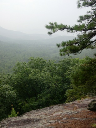
side trail leading left to a fantastic view from a rock face. Here,
the horizon stretches southward from east to west. This is one of my
favorite views anywhere. I used a picture from this point for the
cover of my book, Long Trails of the Southeast. The wide and
long rock slab opens the world before you. Craggy pines hang on to
the margins and provide a green frame for the vista. The two knobs
of Doubletop and the point from where you came are quite evident.
Below, the valley of Ramey Creek opens the mountains to the south
and west. Flat Top is a great place to view fall colors and is
simply one of those special out-of-the-way places that will remain
less visited no matter how much publicity it receives.
Beyond the vista, the BT comes
alongside a trickling branch. This spring creek runs beneath laurel
and rhododendron with an overstory of squat oaks. A small but mostly
level campsite lies on the far side of the spring creek. The path
begins ascending the south slope of Flat Top Mountain, passing
through a prescribed burn area. The young trees are regenerating –
chestnut oak and pine. In summer they grow closely to the trail,
crowding the foot bed, along with briars and brush. Some views open
between the uncanopied spots as the trail switchbacks up. Better
views open when the trail levels off, along the east slope of Flat
Top. A spur trail leads right to a spring here.
Flat Top Mountain runs out of
mountain, so the Bartram Trail descends off it to reach Saltrock
Gap. Saltrock Gap got its name from the practice of leaving slat
licks for cattle that would graze high in the mountains during
summer. Often times farmer would hollow out a log or, in this case,
use a natural depression in a rock, to leave salt for cattle. These
cattle are part of what kept Rabun Bald an open grassy peak. The
forest has regenerated after the grazing ceased. Continue through
the wide gap to a split in the trail at mile 2.8 miles. At Saltrock
Gap, the Bartram Trail leaves sharply right, and an obvious roadbed
keeps forward into a rhododendron thicket. If you continue forward
on the old roadbed it reaches a small brook. The Bartram Trail
switchbacks uphill, where a tiny spring crosses the trail at mile
3.3. Keep ascending to reach Flint Gap and trail junction at mile
3.7. An inscribed boulder marks the spot. To the left, a blue-blazed
trail leads toward Flint Gap.
The BT keeps forward, then
turns right and begins switchback after switchback. The trail is
working up the west side of Rabun Bald through low-slung mountain
laurel, oak and birch. Just when you think the mountain has no top
you make the knife edge crest of the ridge, reaching the top of
Rabun Bald and an inscribed rock at mile 4.5. Uphill to the right is
the stone viewing tower, elevation 4,696 feet, Georgia’s second
highest peak. Steps lead to the top of the tower and a wooden
platform. Here is a 360-degree view and what I believe to be
the best vista in Georgia. Part of this rating is based on the
effort needed to get here, as opposed to the .6 mile trek up to the
state’s highest point, Brasstown Bald, that also has an auto shuttle
leading to the top. To the north are stone-faced mountains, like
Flat Top Mountain you passed, forming a rampart in the Tar Heel
State, North Carolina. The Little Tennessee River Valley is dotted
with small communities to your west. To the east are the Cherokee
Foothills of South Carolina and the Piedmont beyond. To the south
are the North Georgia Mountains and the Piedmont fading into the
sky. The Three Forks Trail mentioned on the inscribed rock is now
called the Rabun Bald Trail, also described in this book, and leaves
right 2.9 steep miles to Hale Ridge Cemetery Road. From this point,
the Bartram Trail soon enters North Carolina and makes its way to
meet the Appalachian Trail at Cheoah Bald.
How to Get There
From just north of the
junction of US 76 west and US 441 in Clayton, head east on Warwoman
Road and follow it for 9 miles to Sarahs Creek Road. Sarahs Creek
Road is on a downhill right curve and is easily missed. Turn left
onto Sarahs Creek Road, Forest Road 156, and follow it for 2 miles
Sarah’s Creek campground. There is an auto ford at this point. Just
beyond the auto ford, turn left onto Forest Road 155, and follow FR
155 for 7 miles to the Bartram Trail, which leaves north from the
forest road. Look for the yellow blaze markers on the trees at the
gap leaving right, into the woods and away from the road. The trail
will be on your right, and marked with an inscribed boulder
indicating the Bartram Trail. If you go too far, there will be an
inscribed stone to the left of the road at Wilson Gap, .5 mile (The
BT follows FR 155 for .5 mile at this juncture) beyond the correct
portion of the BT for this hike.
|

